It was cold in Colorado, but this winter, students in Lisa Jenkins’ sixth grade language arts class were reading about somewhere even colder. Through Elizabeth Cody Kimmel’s Ice Story, students learned about Sir Edward Shackleton’s 1914 journey to reach and cross Antarctica. This nonfiction story’s twists and turns make it as engaging as any thriller, and Ms. Jenkins wanted her her class to see that writing nonfiction could be as fun and creative as writing a made-up story. Enter Lighthouse: outreach instructor Kim O’Connor visited the class and invited students to play with facts. In an honest way, of course.
Ms. Jenkin’s students are amazing! They wrote screenplays, blog posts, magazine articles, personal essays, guidebooks, and more, all based on an element of Ice Story. The Young Writers Blog is proud to feature three of their fabulous non-fiction pieces, “Iceberg on the Move” by Ella Pastorius, “Vikings vs. Shackleton: Could the Viking Explorers Have Completed Shackleton’s Famous Journey from Antarctica to South Georgia a Thousand Years Earlier?” by Jonathon Asphaug, and “Frostbite and All the Icky Side Effects” by Natalie Parkhust, below.
Iceberg On the Move
By Ella Pastorius

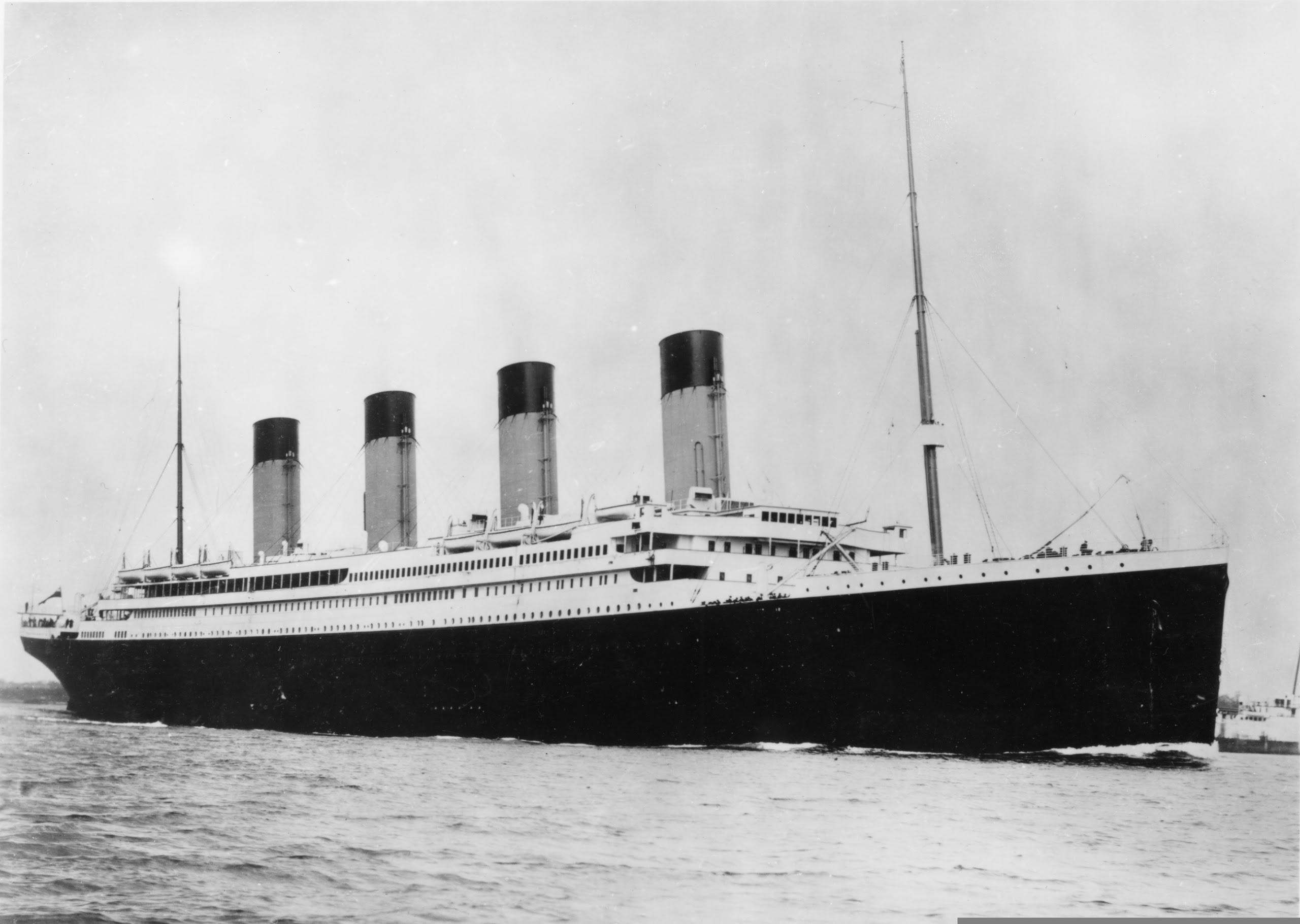
“I cannot imagine any condition which would cause a ship to founder. I cannot conceive of any vital disaster happening to this vessel. Modern shipbuilding has gone beyond that.”
-Captain Edward Smith of Titanic
On the night of April 14, 1912, the Titanic struck an iceberg and after just 2-3 hours, the Titanic was at the bottom of the Atlantic Ocean floor.
Just imagine boarding the Titanic. It’s a beautiful massive ship, the first of its kind. No one has ever been on a ship like this one and you’re one of the first to travel across the Atlantic on it. The Titanic was claimed the “Unsinkable” and of course almost everyone believed it. “God himself could not sink this ship!”
-Unknown Titanic crewmember
The Titanic carried more than 2,200 passengers including the crew. Over seventeen hundred people died from the sinking of the Titanic. Not having enough lifeboats for all the passengers on the ship resulted in many drowning or freezing to death. But, where is the iceberg that created this huge event in history?
Jakobshavn Glacier
No one knows for sure what iceberg hit the Titanic, since of course nobody is going to grab their camera and snap a picture in that scenario. But, people think they might have found it.
An iceberg in the Atlantic Ocean has a red streak of paint on it supposedly from when it hit the ship. It also has the features of an iceberg that has been struck by something like a ship. We’ve also discovered that the glacier that spawned (created) the iceberg that is said to have sunk the Titanic, is moving. Jakobshavn is the glacier that gave “birth” to the iceberg. Jakobshavn is now moving at top speed of almost 46 meters per day! Scientists say that this is four times as fast as it was traveling in the 1990s. The glacier is moving at record speed of the fastest moving glacier in Greenland ever recorded.
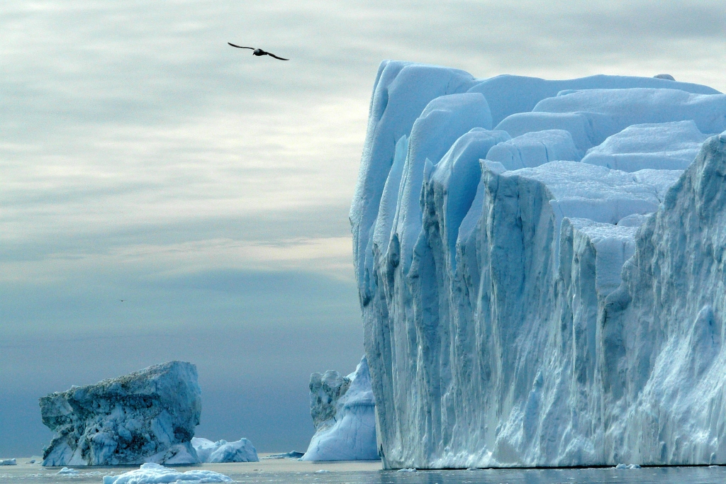
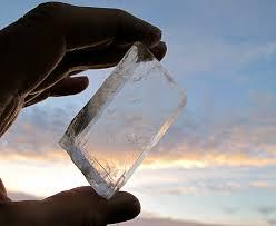
Icebergs
But, what is an iceberg? Icebergs are large chunks of ice that form on land and float in an ocean or a lake. But, in this case the iceberg spawned from a large glacier. A chunk of ice departed from the glacier creating the iceberg. Icebergs come in all shapes and sizes. Some can even be the size of a small country! Smaller icebergs are also known as growlers, bergy, and bits. Icebergs are also smaller than glaciers. In fact, glaciers are the largest moving object on the planet.
The iceberg to the right is the one that is claimed to
have hit the Titanic. It has a red streak of paint and dent fit
for a ship that has struck it.
We still have many unanswered questions about the Titanic itself. We also have many questions on Jakobshavn glacier. Will this glacier soon start to move even faster? Are there more tragedies related to this glacier? But, most importantly, where is this glacier headed next?
Bibliography:
http://www.dailymail.co.uk/sciencetech/article-2130406/Youve-heard-Titanic-major-player-worlds-famous-disaster–iceberg.html
http://www.independent.co.uk/news/science/that-sinking-feeling-the-glacier-which-may-have-sunk-the-titanic-is-now-moving-at-record-speeds-9104937.html
http://www.csmonitor.com/Science/2014/0204/Glacier-that-sank-the-Titanic-is-really-on-the-move-say-scientists
http://nsidc.org/cryosphere/quickfacts/icebergs.html
Titanic: The Unsinkable Ship

Vikings vs. Shackleton: Could the Viking Explorers Ha ve Completed Shackleton’s Famous Journey from Antarctica to South Georgia Island a Thousand Years Earlier?
by Jonathon Asphaug
Most often recognized for their barbaric, violent nature, Vikings were also some of the most seafaring explorers and excellent traders ever known. When it came to navigation, Vikings were the kings of their time period. They were some of the best seafarers and may have reached all the way to North America … by accident! The tools that allowed these warriors to explore so far west were simple, yet effective.
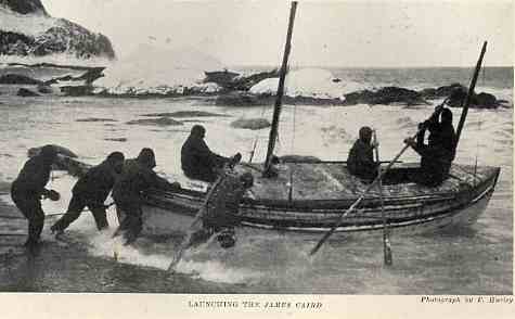
Maybe the king of seafaring exploration for his time period – 1,000 years later – was an Irishman named Sir Ernest Shackleton. On December 5, 1914, Shackleton and his trustworthy crew set sail from South Georgia in the Sandwich Islands on an ill-fated trip. Their plan: execute the Imperial Trans-Antarctic Expedition, or in simpler words, trek across the Antarctic. The built in a Norwegian shipyard, soon became encased in pack ice and sank. After floating on the ice several months, the men eventually decided that as the ice broke up, it was time to leave. They packed up what little gear they had left and traveled seven days on perilous seas in three tiny lifeboats to reach nearby Elephant Island. After landing, the wind and approaching winter took its toll. Shackleton and his men decided rescue was not coming and they had to save themselves. Shackleton and five other men – carpenter Harry McNeish, sailors Tim McCarthy and John Vincent, seaman Tom Crean, and the ship’s faithful captain and navigator, Frank Worsley – left on their famous 920 mile voyage to a whaling colony on South Georgia Island. In a ship only 22.5 feet long called the , this was going to be a near impossible journey. But they successfully completed it in what is perhaps the greatest feat of seamanship ever.
Maybe the king of seafaring exploration for his time period – 1,000 years later – was an Irishman named Sir Ernest Shackleton. On December 5, 1914, Shackleton and his trustworthy crew set sail from South Georgia in the Sandwich Islands on an ill-fated trip. Their plan: execute the Imperial Trans-Antarctic Expedition, or in simpler words, trek across the Antarctic. The Endurance, built in a Norwegian shipyard, soon became encased in pack ice and sank. After floating on the ice several months, the men eventually decided that as the ice broke up, it was time to leave. They packed up what little gear they had left and traveled seven days on perilous seas in three tiny lifeboats to reach nearby Elephant Island. After landing, the wind and approaching winter took its toll. Shackleton and his men decided rescue was not coming and they had to save themselves. Shackleton and five other men – carpenter Harry McNeish, sailors Tim McCarthy and John Vincent, seaman Tom Crean, and the ship’s faithful captain and navigator, Frank Worsley – left on their famous 920 mile voyage to a whaling colony on South Georgia Island. In a ship only 22.5 feet long called the James Caird, this was going to be a near impossible journey. But they successfully completed it in what is perhaps the greatest feat of seamanship ever.
This article explores whether the Vikings, with their navigational and survival methods, would have been able to complete Shackleton’s journey. Could their more primitive style of navigation, ships and other tools, yet used by them for hundreds of years, have been as successful as Shackleton’s better technologies but more improvised methods?

To answer this question, this article will first examine the Viking methods of navigation, their ships, their clothing and food in detail, and then Shackleton’s versions. The sources for this article are not only books and websites, but also an interview with my friend, sailor Geoffrey Pettit, who is half British and half Norwegian, and who has sailed across the Atlantic Ocean alone in a tiny sailboat and written a book about his adventure called “A Drop in the Ocean.” Based on his experiences and knowledge of both cultures and histories, Mr. Pettit has some expert opinions on who would have been better at the journey to South Georgia Island.
1. The Vikings and Their Equipment
The Vikings, perhaps the most romanticized of all warriors, were impressive seamen and navigators. They traveled all over Europe and even settled North America for a brief period of time, using their gargantuan longships: some of the biggest ships of their time. The Viking longships ranged from 55-100 feet long and 8-10 feet wide, with the longest one ever found being about 118 feet long and 13 feet wide and capable of holding about 100 men.
Navigation
The Vikings had several tools that were used for navigation. These tools helped them travel far and wide, even though the Vikings never made maps or charts.
The most common way for sailors and merchants to navigate in the Viking era was usually by celestial bodies: the stars and the sun. The North Star, or Polaris, was the primary instrument for navigation at night. All that had to be done was compare the distance from the star to the horizon to the distance at home and sailors could roughly determine their latitude.
For navigation in the daytime, stars could not be seen, so almost all the rest of the Vikings navigational methods relied on the sun.
The pelorus was an instrument similar to a mariner’s compass. It had two sight vanes and was positioned in a way so that the bearings of objects could be observed.
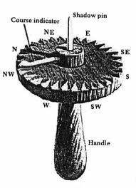
A bearing dial was used to determine the latitude of the sun. It was a small platform with a vertical pin in the center, and a pointer needle. It was used to track the placement of the sun in the sky by marking the position of shadows on the platform.

The sun shadow board was used at noon to check if the ship was on the right course or not. It was placed in a bowl of water (similar to liquid-filled compasses used on modern ships) to keep it level. The gnomen, the pin in the center of the board, marked the shadow of the noon sun. Circles that were marked on the board gave sailors an area to travel yet still remain within the desired latitude. If the noon shadows reached beyond the circle, they knew that they had traveled too far north; vice versa for tracking too far south. The sun shadow board allowed the Vikings to correct their course each noon.
The semi-wheel was pretty much a database of the sun. It recorded the year-round observations and measurements of the sun and its positions. Icelandic Vikings collected this data, and also noted where the sun rose each day. This collection of data was used to determine their latitude and the cardinal directions (North, South, East, and West).
The sun compass recorded the routes that the sun traversed across the sky. By etching these curves on the face of the compass, the Vikings had documentation of the sun for any time of year. They could with incredible accuracy pinpoint their location at sea by revolving the dial until the shadow from a center pin touched the curves for that time of year.

There is one tool that stood out above the rest, because only one has ever been found. In an old Norse legend, a hero, Sigurd, is asked by a Viking king to locate the sun through blustery, overcast skies. When Sigurd guessed, the king confirmed his answer by using a Sólarsteinn, or sunstone. The king saw where the light came from and realized Sigurd was correct. A sunstone was a simple block, about the size of a bar of soap, of pure Icelandic spar, a variety of calcite that polarizes light. It changed color as it was turned in the light. A certain color would indicate the position of the sun through fog or clouds, but it still needed a tiny piece of clear sky to work. It would have allowed travelers to navigate with cloud cover and in low light. Scientists are not sure that the sunstone was used in Viking times, since it was only mentioned in one Norse manuscript, but they do know that one was used in Elizabethan times, 500 years later.
Besides these many tools that the Vikings used to navigate, they also used their memory and all of their senses. They sometimes used rhymes or chants to remember landmarks and directions, kind of like how today people remember nursery rhymes or jingles for a certain store. They could see from the presence of certain birds and other animals how far away from land they were, or where they were in general. Viking mariners could hear the crashing of waves on rocks and the screeching of seabirds to find how close they were to land, when it was too foggy or dark to see. Touch was another important sense for the Vikings: nerves in our faces can detect changes in speed and direction of wind. Our faces can detect differences between wind swells from various directions, and because nearby coasts sometimes will reflect swells back, a seasoned sailor can obtain much information from just a simple breeze. Scientists have hypothesized that the Vikings used these methods.
The Vikings had another instrument, called a plumb bob, which they used for calculating the depth of the water, and it also collected a small sample of the seabed that the men could taste and touch. Using a plumb bob, an experienced Viking could possibly link the taste to to certain characteristics, such as if fresh water flowed from the land to the sea.
A good sailor can also detect in humid conditions whether or not he is close to land. In humidity, the human nose can smell trees, plants, and fire a good distance from land. Vikings probably used this same method.
In conclusion, as Mr. Pettit wrote to me, “the Vikings had to rely much more on their senses and understanding of nature, following indications from bird sightings (closeness to land), whale sightings ( they knew where the whaling grounds were), their sense of smell ( you can smell the land from quite a long way away), and their rudimentary understanding of the position of the heavenly bodies.” Mr. Pettit explained, “They invariably tried to follow the land as much as possible, island hopping across the North Atlantic via the Shetlands, the Faeroes, Iceland, Greenland and then the Canadian coast. Of course, they made many more mistakes and many ships were lost, so you could conclude that they were not as good at navigating as the 19th and 20th Century explorers, but they were very good given the limitations in their historical context.”
Ships and Sails
But survival at sea was much more than just being able to navigate. Mr. Pettit told me: “The issues that normally concern sailors other than navigating are the weather, equipment failures, food and drink and staying warm and dry. Without taking care of these things then good navigating might just not be enough to survive a long ocean voyage.” How well prepared were the Vikings to deal with these issues?

Mr. Pettit told me that the Viking ships were good but could sink in bad weather: “Viking ships were open and therefore less safe although they were broad with high bow and stern to make them more seaworthy in rough seas. But I am sure many a longship foundered after being inundated by a breaking wave. These waves can reach 20-30 meters in height and when they break it is like the force of a building crashing down on your boat.”
Mr. Pettit also talked about the Viking-era sail structure: “The Viking ship’s single square sail, although it could be moved around the mast to provide some form of crosswind sailing, was almost impossible to sail upwind and was far less efficient and therefore inherently less safe (than later methods). They could resort to using the oars, but not for long periods and not in the heavy seas that frequent the Southern Ocean.”
Food and Warmth
As for quality of food, Mr. Pettit said, “Vikings carried white cabbage, Surkål, which contains large amounts of vitamin C.” This would help ward off scurvy. In addition, he noted that “the Viking journeys were relatively short, touching land regularly as this was also the way they navigated, and they would have been able to replenish their fresh fruit and vegetable supplies.”
For staying warm and dry, the Vikings were well experienced with the cold ocean sea spray and what clothes to wear on these long voyages. They wore animal skins and wool, which dried out quickly and kept them warm even when wet. In addition, their ships were protected from overflowing water by roofs and tents spanning the entire deck. They used pine tar to waterproof their ships.
2. Ernest Shackleton and His Equipment
A thousand years later, when Shackleton and five men pushed off from Elephant Island in their little reinforced lifeboat to embark on their 920-mile journey to South Georgia Island, his boat wasn’t that much different from the smallest Viking longship but his navigational tools were much better.
Navigation
Although he had to rely on several of the same methods that the Vikings would have used, such as being able to spot, smell and hear land, Shackleton and his crew mainly used 20th-century navigational methods such as the sextant, chronometer, and compass.
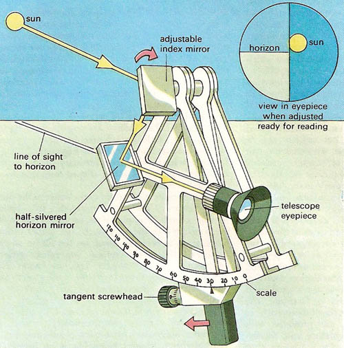
A sextant is an instrument that measures the angle from a celestial object to the horizon, by using two mirrors and an index bar, and can be used in multiple ways. You look into the eyepiece, and adjust the angle of the index mirror until the celestial body that is sighted “touches” the horizon.
A chronometer is a little instrument resembling a pocket watch that is used to measure the time of a known fixed location. This can be used to calculate longitude. The picture at the right is the chronometer that Shackleton and Captain Worsley used on their voyage to South Georgia Island.
Most people have heard about the magnetic compass. It is used to find the cardinal directions, and combined with a sextant, chronometer, and map, can find a very accurate reading of where you are heading, it can also be use to help plan your next course. Shackleton had a compass as well, and it could have helped him plotting the course for South Georgia Island. However, there’s a downside to using a magnetic compass: the bearings change slightly as you travel on a set longitude. This happened on Christopher Columbus’s first voyage to the New World, but he didn’t tell his men because he didn’t want to frighten them.
Our family friend Mr. Pettit told me about his experience with a sextant and chronometer:
“I always carried a sextant on board with all the necessary nautical almanacs to take and calculate sightsof the heavenly bodies, either the sun or the stars. This is the old fashioned way of ascertaining your latitude and can be quite a complicated exercise in any boat let alone a small boat like the James Caird. But I guess this is what Captain Worsley on the James Caird did and I am sure he was an expert. Longitude is normally calculated using a ship’s chronometer which always tells the time at Greenwich in London on Meridian 0. If you know the time where you are by taking a midday sun sight and you know the time at Greenwich then you can calculate the difference in longitude degrees. This was very difficult until they invented chronometers that could stand the bouncing around on a long sea journey, but it was finally achieved by a brilliant watchmaker called John Harrison. His H4 chronometer was invented in the 18th Century and was used by Captain Cook on his last two voyages of discovery in the 1770s. Captain Bligh, who was a brilliant navigator and was on Captain Cook’s last voyage, would also have used a sextant and chronometer to navigate in the open ships boat after he and some of the crew of the Bounty were set adrift following the mutiny.”
Mr. Pettit said that Shackleton might have also used a technique called dead reckoning: “Another way of navigating is by dead reckoning. You know your starting point, and by trailing a patent log line over the stern of the boat and following a compass course you can check your speed and calculate the distance traveled from the log line, albeit not necessarily in a straight line, especially in a sailboat! So you need to make corrections to your position quite often and each time you change course, to allow for wind and current pushing you off your course line. Dead reckoning was often used by solo sailors before the invention of GPS to compare their sextant position to their dead reckoning position. Their real position would often be somewhere between the two!”
Ships and Sails
As with the Vikings, Shackleton’s equipment consisted of more than navigational tools. First of all, Shackleton’s vessel was not built for crossing such large areas of water. Remember, his ship was a lifeboat, not an expedition boat. But Shackleton had taken steps to make his lifeboat more seaworthy in the rough polar seas.
Mr. Pettit explained: “I know that Shackleton was a very good planner and always had safety paramount in his mind. He is after all well known for not losing a man in the course of his expeditions unlike many other explorers, Captain Scott for instance, who lost many expedition members and his own life on his final attempt to reach the South Pole. The open boat journey to South Georgia was especially well planned, and one of the major changes Shackleton made was to cover over the open decks with board to provide some shelter for the crew and also to prevent the small boat being swamped by giant waves. After all, he was crossing the latitudes of the Southern Ocean where there are no continental land masses slowing down the wind which whistles round the planet without let-up, often building up very large seas.”
The James Caird was an English-built lifeboat designed as a lighter version of the standard British lifeboat, and was a double-ended whaler. The boat had been modified by the carpenter Harry McNeish under Shackleton’s and Frank Worsley’s orders long before, when the Endurance had been trapped in pack ice, because they knew the pack ice would not break up and they would perhaps need to perform a long-distance sea journey.
To reinforce the boat, they raised the prow and stern much higher, and also raised the sides of the boat up to 15 inches higher. They also reinforced the bottom with bits of copper and other spare metal. On Elephant Island they added over 1,000 kilograms of ballast – rocks, boulders and debris – to keep the boat upright. They further modified the boat by making an almost tent-like structure out of a mixture of raw materialsuch as board and planks, covered with canvas and treated with a waterproof mixture of seal blood, oil paint, and candle wicks.
It was a good thing that they did this, because as Shackleton describes here, the James Caird faced incredible danger:
“I called to the other men that the sky was clearing, and then a moment later I realized that what I had seen was not a rift in the clouds but the white crest of an enormous wave. During twenty-six years’ experience of the ocean in all its moods I had not encountered a wave so gigantic. It was a mighty upheaval of the ocean, a thing quite apart from the big white-capped seas that had been our tireless enemies for many days. I shouted For God’s sake, hold on! it’s got us.’ Then came a moment of suspense that seemed drawn out into hours. White surged the foam of the breaking sea around us. We felt our boat lifted and flung forward like a cork in breaking surf. We were in a seething chaos of tortured water; but somehow the boat lived through it, half full of water, sagging to the dead weight and shuddering under the blow. We bailed with the energy of men fighting for life, flinging the water over the sides with every receptacle that came to our hands, and after ten minutes of uncertainty we felt the boat renew her life beneath us.”
Sails were a huge advantage of Shackleton’s boat. Although Shackleton had a very small boat, he was able to use his sails to an advantage because he could sail in any direction. As Mr. Pettit told me, “The James Caird‘s gaff mainsail and triangular foresail made her easier to sail into the wind” than the single square sail of Viking times.
Food and Warmth
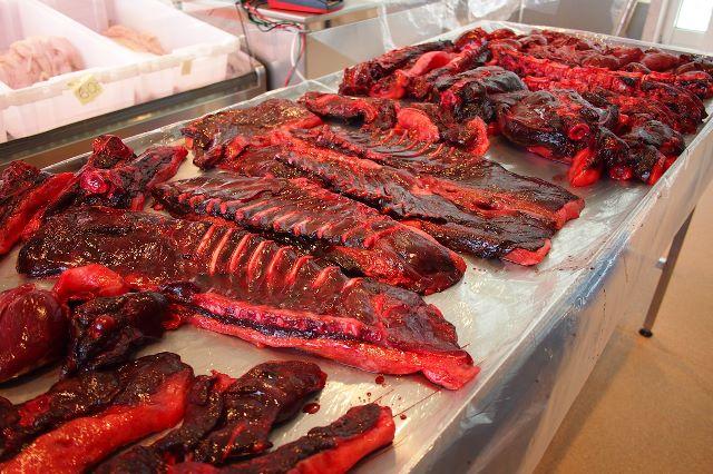
By Shackleton’s time, people knew what caused scurvy and how to prevent it: lots of vitamin C. Although vitamin C was hard to come by on the open ocean, Shackleton knew that raw seal meat – like the gruesome cuts on the right – contained lots of vitamin C. As Mr. Pettit said to me, “I’m pretty sure that Shackleton was better off on all counts than the Vikings, not least in providing sufficient vitamin C to ward off scurvy.”
As for keeping warm and dry, there simply was no such thing among Shackleton’s tiny crew. Their clothing had not been changed for seven months. It was soaked with salty seawater, and rubbed their legs raw. Shackleton and his men had not prepared for being on the open ocean so long. The clothes he had taken were intended for trekking across Antarctic ice and snow, so his experience was like you wading around in an alpine lake in your ski clothes.
Shackleton’s Other Advantages
Finally, Shackleton had technology that the Vikings might never have dreamed of: the ability to predict the weather. “I think Shackleton had some expertise on board for weather forecasting which would not have been available to the Vikings. Shackleton’s men would have had the use of a barometer for measuring air pressure and would have understood its significance in forecasting bad weather. They would also have been able to interpret cloud formations and not least squall clouds which in themselves can be very dangerous.”
3. Who Would Have Completed the Voyage Better: the Vikings or Shackleton?
My friend Mr. Pettit believes that Shackleton would have done better than the Vikings on all accounts in sailing to South Georgia Island from Elephant Island, even though he respects the Vikings for their abilities of their time. “On balance,” Mr. Pettit said, “I think Shackleton would, and indeed did, make a safer and easier passage to South Georgia than the Vikings could ever have done.”
One factor that may have been in Shackleton’s favor was the temperature. The average temperature for Iceland around where the Vikings lived is about 6° C. The average temperature for South Georgia Island is -7° C. This means that Vikings taking Shackleton’s route would have had a rude shock.
As for navigation, I think Shackleton and the Vikings may have been tied. Shackleton had better equipment, but Vikings had many more methods that could be used in almost any situation. “Modern navigators using GPS are certainly not as good at navigating as Captain Cook, Captain Bligh or Captain Worsley even though they know exactly where there are 24/7,” Mr. Pettit said. “What would happen if the GPS system went down for several weeks? They would have to get out their sextants and chronometers and I’m sure these are still carried on most ocean going vessels today. But can they use them? I’m sure their positions would be pretty inaccurate until they had used the sextant again and again. So to answer the question, I think the Vikings were better navigators as they used all their senses and lived more at one with the ocean.”
Shackleton definitely had the advantage with ship structure, because his vessel was modified for long distance travel in rough seas, including being covered. The James Caird’s sails also would have worked better when sailing into the wind than a Viking ship’s because of their shape.
I think Vikings had a huge advantage when it came to staying warm and dry, because they wore naturally warm and dry clothing such as wool and animal hides, while Shackleton wore clothes that were not intended for ocean travel.
As for food, I am not sure who had the advantage, because the Vikings could have caught seals like Shackleton did. They might not have known that they were preventing scurvy in the process, but they would have been able to do so.
Who would have done it better? The world will never know. But we do know that both the Vikings and Shackleton were excellent seafarers, and they both tackled rough seas and new lands.
A special thanks to my family friend Geoffrey Pettit, for taking his time to answer my many questions about Shackleton and the Vikings in such helpful detail.
Bibliography
Images (in order of appearance):
Photo of Shackleton’s crew launching the James Caird:
http://www.gutenberg.org/files/5199/5199-h/images/054.jpg
Picture of Geoffrey Pettit’s book: http://www.amazon.com/Drop-Ocean-Geoff-Pettit/dp/0956298419
Map of Viking travels: http://3.bp.blogspot.com/-s_pT5Men_jM/TXO8mJrJIDI/AAAAAAAAAeg/ae7s3ET4Jpw/s1600/Routes%2Bof%2Bthe%2BVikings.jpg
Picture of sun compass:
http://t3.gstatic.com/images?q=tbn:ANd9GcS5mlt8RrEYpgleNdF5bc1b9PawpWZcqBHi2_Zciog0TBTVApoUWQ
Picture of sunstone:
http://upload.wikimedia.org/wikipedia/commons/1/14/Silfurberg.jpg
Picture of longship: http://t2.gstatic.com/images?q=tbn:ANd9GcR1AX1T2QaYsotHC4s6ry802NbClqo8usH4pvIUT9
p16M2Ksq6o2A
Picture of Shackleton’s chronometer:
http://upload.wikimedia.org/wikipedia/en/8/89/Mercer_chronometer_used_by_shackleton.png
Picture of sextant:
http://www.daviddarling.info/images/sextant.jpg
Picture of dead reckoning:
https://encrypted-tbn3.gstatic.com/images?q=tbn:ANd9GcTb4UiXUkvGJcgNtxv45eLXYEyvKD3C-BAnQmbgcIKxnNhMCpCM
Frostbite and all the icky side effects
by: Natalie Parkhurst
In the frigid Arctic, two men hurry across the snowy plain. Fingers going numb, one takes off his gloves, to find the skin black and blue, frozen to the bone. Frostbite. Frostbite is the freezing, or death of skin cells when exposed to freezing temperatures. When the body is exposed to temperatures too cold for the human body to handle, the core must be protected, so circulation is cut off from fingers, toes, your nose, and other areas, all to keep the major organs warm.

There are three degrees of frostbite:
First degree:
- White skin
- numb
- can be treated
- outer layers frozen
- inner layers warm
Second degree:
- white or blue
- hard or frozen to touch
- hard to treat
- permanent damage more likely
- need professional help
Third degree:
- hard, frozen skin
- blue or white coloring
- blisters, swelling
- cold all throughout area
http://www.summitpost.org/images/original/856322.jpg
This is what frostbite looks like. The
discoloration and swelling are common for frostbite victims.
How to Prevent:
To prevent frostbite, stay out of the cold. On frigid days, bundle up, or don’t go outside. Don’t venture out in freezing weather when wet, and put a hat on to preserve your body heat. Bring extra clothes on camping, hiking, or backpacking trips, or anywhere you know you will be a while without access to home. Wear layers of clothing, so you can always take something off or put something on, depending on the conditions. These and many more are ways to help prevent frostbite, so you don’t have to treat it in the first place.
How to Treat:
If you happen to get frostbite anyways, then treating it is simple, but must be done with haste. This is for first and possibly second degree frostbite. If very severe, you must get professional help.
- use direct heat such as a heater, or a warm tub.
- remove wet items and clothing from frostbite victim.
- do not thaw the affected area, for that could cause permanent damage.
- Warming can take up to 40 minutes.
Anybody can get frostbite. But there are some people who are more prone to receiving it, such as snowboarders or skiers. Soldiers assigned to cold areas, the extremely old or young, smokers, and homeless people. These people are more likely to have frostbite, for they are surrounded by the cold, or have constricted blood vessels. Take precautions, and dress appropriately in severe weather.
A little thing, like frostbite, can lead to a much bigger problem, such as amputation. As you can see, frostbite is serious and dangerous, and will be severe if not treated immediately. But if you use common sense, then you can avoid treating it, by not letting it happen.


